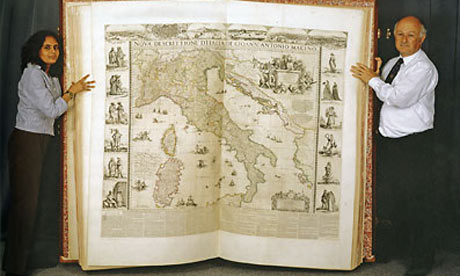
What you're looking at, as reported in the Guardian, is the world's largest book, the Klencke Atlas. It will be displayed for the first time by the British Library as part of an exhibition on maps. The idea behind the exhibition is to challenge the assumption that maps are primarily the products of a scientific function, the products of accuracy or measurement.
Instead, the organizers want to display the maps as both pieces of art and as instruments of propaganda. The article quotes Peter Barber, the library's head of map collections:
Barber said the maps were all made for adornment but "at a deeper level they were made for propaganda. It's all spin. Every map is an exaggeration because you can never 100% capture reality on a reduced surface.
"Up until 1800 people expected maps in these contexts and enjoyed them, but in the course of the 18th century you got the growth of the cult of science, the belief that maps were to do with geography and the only thing that was important was its accuracy."
Now if the qualification for curating is artistic merit and ideological efficacy, the perfect map is the "Surrealist Map of the World" (1929) (full image). While it is often lauded for its childlike qualities (its playfulness), the map must be scanned politically. The surrealists were attacking the convention that a map is a scientific document that is politically neutral. Europe and the United States are largely removed to show the rest of the world, to invert the perceived relationships (political, moral, aesthetic, economic) between the West (from the Western perpective) and the rest of the world.

1 comment:
While I am always reading historically grounded critiques of maps I love them. I recently got Penguin's State of the World Atlas for 2006 and have devoured it. Great review!
Post a Comment